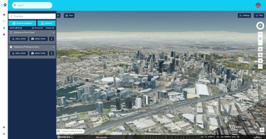
Get ready to explore the world like never before! SpatialScale has just added a treasure trove of...
Exploring Point Cloud Collections
The world of geospatial data is constantly expanding, and with it, the tools available to professionals like you. SpatialScale’s Discover module now includes a rich collection of point clouds, offering you unprecedented access to high-resolution LiDAR (Light Detection and Ranging) data. These point clouds are essential for anyone looking to conduct detailed terrain analysis, urban planning, or environmental monitoring.

USGS 3DEP: Mapping the United States in High Detail

The United States Geological Survey’s 3D Elevation Program (USGS 3DEP) offers a comprehensive LiDAR collection that covers large portions of the U.S. This program aims to map the entire nation with high-precision elevation data, which is invaluable for projects ranging from flood risk management to infrastructure development. With SpatialScale, you can easily access and ingest these datasets to enhance your geospatial analysis.
- Coverage: Extensive coverage across the U.S., with particular focus on areas prone to natural disasters.
- Program Details: Supported by federal, state, and local government agencies to create a national standard for elevation data.
NRCan LiDAR Point Clouds: Precision for Canadian Terrain

For those working with Canadian landscapes, the Natural Resources Canada (NRCan) LiDAR point clouds provide unparalleled precision. These datasets provide detailed elevation models that are crucial for forestry management, natural resource exploration, and environmental protection. With SpatialScale, accessing this data is straightforward, allowing you to focus on what matters—your analysis.
- Coverage: Comprehensive coverage across Canada, including remote and difficult-to-access regions.
- Program Details: Managed by Natural Resources Canada, these datasets are part of the national effort to support sustainable development.
Why Point Clouds Matter
Point clouds are more than just a collection of data points; they are the foundation of precise geospatial analysis. Whether you're using a LiDAR drone to capture data or relying on government-sourced datasets, point clouds offer the accuracy needed to make informed decisions. With the SpatialScale platform, you can easily discover, ingest, and analyze these datasets to unlock new insights in your projects.
Explore More with SpatialScale
Ready to dive into the world of point clouds? Visit SpatialScale to explore the available collections and start your analysis today. For detailed guidance on using the Discover module, check out our help center.


