Get ready to explore the world like never before! SpatialScale has just added a treasure trove of...
Have you ever thought about how much data the world generates every second? It’s staggering! Now imagine trying to make sense of all that geospatial data without any help. Enter GeoAI—a game-changer that combines artificial intelligence with geospatial technology to make your life easier.
.%20The%20scene%20should%20feature%20a%20mix%20of%20nat.webp?width=960&height=549&name=DALL%C2%B7E%202024-08-09%2012.49.57%20-%20A%20visually%20engaging%20image%20depicting%20a%20landscape%20being%20analyzed%20using%20GeoAI%20(Geographic%20Artificial%20Intelligence).%20The%20scene%20should%20feature%20a%20mix%20of%20nat.webp)
Introduction to GeoAI
GeoAI, or Geospatial Artificial Intelligence, is the magic wand that turns complex geospatial data into actionable insights. Whether you're working with drone imagery, LiDAR scans, or traditional GIS data, Artificial Intelligence can help you process and analyze it quickly. The best part? You don’t need to be a data scientist to understand the results.
Benefits for Drone Surveying
If you’re using drones for surveying, AI is your new best friend. It enhances your drone photography by analyzing and classifying the data in near real-time. Imagine flying a drone over a construction site and instantly knowing which areas need attention. GeoAI makes that possible by processing the geospatial data on the fly, helping you make quicker decisions.
LiDAR Meets AI
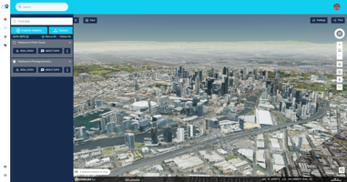
LiDAR technology is already impressive, but when combined with artificial intelligence, it becomes unstoppable. GeoAI helps you analyze LiDAR data with remarkable accuracy, whether you’re mapping terrain or detecting changes over time. SpatialScale, for example, uses AI for point cloud classification. This helps in identifying different features in the landscape, from trees to buildings, with pinpoint accuracy.
Future Trends in GeoAI
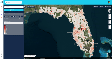
The future of GeoAI is bright and full of possibilities. Imagine smarter cities or digital twins where maps are automatically updated and maintained. Or how about AI predicting landslides by analyzing remotely sensed data in real-time? These aren't just ideas; they're the future of geospatial solutions. As GeoAI continues to evolve, expect even more innovative applications that will make managing spatial data easier and more efficient.
Explore More with SpatialScale
Curious to see GeoAI in action? Head over to SpatialScale and discover how our platform leverages AI for point cloud classification, Landslide Susceptibility products, and more. Want to dive deeper? Check out our help center for detailed guides on how to make the most of our geospatial services.